A Question of Jurisdiction
A Question of Jurisdiction
Still, probably easier to find/define than the coastline of Louisiana...
via Andreas Schou
Originally shared by Paul Cowan
Fun project for Anthony Baxter and I today: trying to work out, once and for all, if the ACT has a coastline.
For you non-Australians: the ACT is the Australian Capital Territory. The place where Canberra is. Think DC in the USA; there are many similarities, including the fact that states donated land to carve out a neutral HQ for the national capital. (Side note: you may see references to the FCT, or Federal Capital Territory, in some of the stuff linked below. It's the same place; it was renamed along the way.)
You'd think "does a federal subdivision have a coastline" would be an easy question to answer. You'd be so, so, so wrong. This is a pub trivia kind of question in Australia; the problem is, most people get it wrong. At best, they get it right, but for the wrong reasons. Like, maybe it does have a coastline, but not the one they think.
At least 3 Wikipedia pages cover the topic. Each of them give different answers to the question.
Regardless, this is a fascinating geopolitical quirk. So here's what we know:
Easy answer: no, it's inland
This is the answer you get when you look up 'Australian Capital Territory' in your favourite online map site, or (heaven forfend) a paper atlas. The ACT is landlocked, as any fule no (cf. http://www.cmd.act.gov.au/__data/assets/image/0004/117526/Australia_map_downsized.jpg). Obviously it doesn't have a coastline, some will say.
These people are wrong.
Pub trivia answer: yes, on Jervis Bay
Some background. When the various states federated into the Commonwealth of Australia (1901), Australia didn't have a capital per se. Melbourne acted as capital, with the promise that they'd sort a real one out later. In 1908, the Seat of Government Act was passed, which basically said "we're going to build something in the Yass-Canberra area, the New South Wales government will give us some land once we've worked out somewhere mutually agreeable". The interesting part is the quote "The territory to be granted to or acquired by the Commonwealth for the Seat of Government shall contain an area not less than nine hundred square miles, and have access to the sea." (emphasis mine). The astute amongst you will note, from your maps, that the "district of Yass-Canberra" is nowhere near the sea. No problem, New South Wales will carve out another bit, on the sea, and pony that over too. The land they chose was at Jervis Bay (https://en.wikipedia.org/wiki/Jervis_Bay), a bay due more-or-less east of Canberra.
So, people say, this land they carved out (you can see it on a map!) is actually part of the ACT. It does have a coast!
These people are wrong.
Advanced double-bluff pub trivia answer: no, Jervis Bay isn't part of the ACT
The next (correct) argument is that the thing at Jervis Bay is not part of the ACT; it's part of the Jervis Bay Territory (JBT), a completely separate part of Australia. This is fairly startling to many Australians; we are all taught that Australia has 6 states (NSW, Victoria, Queensland, Western Australia, South Australia, Tasmania) and 2 mainland territories (Northen Territory and the ACT). But this isn't true; there are three mainland territories. Jervis Bay Territory is, legally, exactly like the other two: an independent top-level division of Australia. Finding out there's a third territory is startling for many Australians: it would be like if the US actually had 51 states, but no-one ever bothered to mention, say, a South Rhode Island. Anyway, it's true. Legally, in Australia, JBT is just like the ACT. The difference is: it's smaller, almost no-one lives there, and lots of people have never heard of it. But that's irrelevant.
Really quite advanced pub trivia answer: the Jervis Bay Territory is PART of the ACT, so yes
This is wrong, as stated above. But people believe it, because of one key fact: the JBT doesn't have a government. Because almost no-one lives there, giving it a government is kind of wasteful. So the ACT administers it. That is, the laws of the ACT apply; commit a crime there, you're tried in the ACT courts. Live there, you vote for the ACT government. But the law is clear; it's as if it's part of the ACT, but it's not. This is an administrative convenience.
Exhausted and confused person answer: so it's no then?
Ahahaha. No.
Epic map nerd smart arse answer: yes, but not the one you're thinking of.
Ahh. Here's where we get really tricky. All that stuff above? You know where I said the "pub trivia answer" people who said "yes" were wrong? Well, they're very possibly right. But for the wrong reasons. There's a completely separate parcel of land, also on Jervis Bay, which may well be part of the ACT.
Look at Bing Maps (no, really): http://binged.it/1nngW39. The Jervis Bay Territory (NOT part of the ACT, as established above) is the thing outlined in green. But that's irrelevant to us. Look north-east of there. See the land at the north headland of Jervis Bay? That's the Beecroft Peninsula. This is in fact the bit of land that may be part of the ACT.
Cadastral surveying nerd answer: a-ha! That's not part of Commonwealth land; Beecroft peninsula is merely leased to to Commonwealth by NSW! So no!
Oh-ho, cadastral surveying nerd, hold up. I'm not talking about all of Beecroft peninsula. In the majority, you're right. But there's one part where I'm not sure you are. See http://i.imgur.com/giylEo1.jpg - I'm not saying A or B are part of the ACT. All I'm talking about is C: the land given to the ACT under the Seat of Government Acts of 1908 and 1922.
That land is part of the Jervis Bay Territory too! So no!
No, it's not. This is actually really quite clear. The Jervis Bay Territory Acceptance Act 1915 (https://www.comlaw.gov.au/Details/C2004C00038; hereafter JBTA) makes it clear what's part of the JBT. See "The Schedule". Following the descriptions is complicated, but this describes the parcel of land on the south headland. It mentions nothing about the North one.
If your argument is based around the JBTA: nope, it's not in there.
If you argument is that a subsequent piece of legislation post-JBTA has changed it: [citation needed], as I'm not aware of any.
THE LAW
So, let's look at the law. There are a few relevant parts here, beyond the ones we've already discussed.
There's the Seat of Government Acceptance Act 1909 (https://www.comlaw.gov.au/Details/C2004C00608). This was actually two acts: this one, and a corresponding one from the NSW Government, the Seat Of Government Surrender Act 1909. That is, NSW passed an act surrendering the land; the Commonwealth passed one accepting it. Each was conditional on the other; both were passed and both came into effect. This does cover the north headland; for example, "Eastern Division, Land District of Nowra, County of St. Vincent, Parish of Beecroft, area five hundred and thirty‑one acres. The Crown lands within the following boundaries: Commencing on the High Water Mark of Jervis Bay at Longnose Point, and bounded thence on the east by that High Water Mark and the right bank of Duck Creek generally northerly to the road leading to Point Perpendicular Light House, thence by that road, generally westerly and north‑westerly to the High Water Mark of Jervis Bay at a wharf, and thence generally on the west and south by that High Water Mark southerly and easterly to the point of commencement. Plan Misc. 1393 Sy." (Yes, it's ALL like this. Gripping). I chose this example deliberately: the lighthouse is recognisably on the north headland, so you know that's where they're talking about. If you follow up on the others, they all seem to be on the north too (with one exception, but let's not go there).
There's the Seat of Government Acceptance Act 1922 (https://www.comlaw.gov.au/Details/C2004C00609; again, there's a corresponding NSW act). This complicates things, but then again… it doesn't. It does because it defines a whole new set of land parcels; it doesn't, because it's the same set. This exists only because _"certain errors and misdescriptions exist in the descriptions of lands set forth in [SoGA 1909]". That is, it's covering the same stuff, but more precisely. Nothing (really) to see here.
There's the Jervis Bay Territory Acceptance Act 1915; the one I cited above. I've already said this is irrelevant; what complicates it a tiny bit is that the corresponding NSW state act was called Seat of Government Surrender Act 1915. Ignore that, it's nothing to do with the Seat of Government. It's totally seperate. They just, like… copied and pasted the name of the 1909 state act, or something. Ignore it.
There's the Australian Capital Territory (Self‑Government) Act 1988 (https://www.comlaw.gov.au/Details/C2014C00617): this is the act that gave the ACT the right to make its own laws. This should be useful, but… it's not. Its entire definition of the actual boundaries of the ACT is "Territory: (a) when used in a geographical sense, means the Australian Capital Territory". That's really helpful, you bastards.
As far as I can tell, that's all the legislation that's relevant.
So, my answer: as far as I can tell, it's unambiguously part of the ACT. It was ceded in 1909 (and clarified in 1922). These acts, as far as I can tell, are the best source we have for defining the boundary of the ACT. If there are other sources, I don't know them.
To address some likely objections:
"The Jervis Bay Territory Act says…" I'll stop you right there. Irrelevant; these acts don't cover the north headland. Ignore JBT, it's a red herring.
"This map says…" Maps don't actually define boundaries. This is an obscure point of geopolitics: it's obvious that many maps don't bother to get it right. Even government maps: we know some of them get it wrong, because many of them disagree. They can't all be right. So which ones are?
"The boundaries have changed since the 1909 Act" [citation needed]. Where? Give me a source dammit.
"NSW ceded the land, and the Commonwealth accepted it. But they didn't make it part of the ACT; it's now just regular Crown [commonwealth-owned] land" Great, good argument. But where is it defined which bits are part of the ACT? Again, [citation needed]. If not the act, find me a source.
In conclusion: damn, I need a stiff drink.
No, wait.
In conclusion: I'm pretty sure it is part of the ACT. But it's deeply murky, and not only do the three goverments seem to disagree on the exact state of this land, but individual sources from the same government do.
Geopolitics is fun!
Still, probably easier to find/define than the coastline of Louisiana...
via Andreas Schou
Originally shared by Paul Cowan
Fun project for Anthony Baxter and I today: trying to work out, once and for all, if the ACT has a coastline.
For you non-Australians: the ACT is the Australian Capital Territory. The place where Canberra is. Think DC in the USA; there are many similarities, including the fact that states donated land to carve out a neutral HQ for the national capital. (Side note: you may see references to the FCT, or Federal Capital Territory, in some of the stuff linked below. It's the same place; it was renamed along the way.)
You'd think "does a federal subdivision have a coastline" would be an easy question to answer. You'd be so, so, so wrong. This is a pub trivia kind of question in Australia; the problem is, most people get it wrong. At best, they get it right, but for the wrong reasons. Like, maybe it does have a coastline, but not the one they think.
At least 3 Wikipedia pages cover the topic. Each of them give different answers to the question.
Regardless, this is a fascinating geopolitical quirk. So here's what we know:
Easy answer: no, it's inland
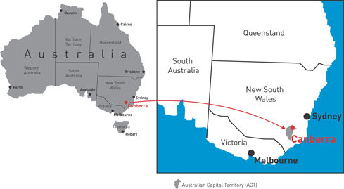
This is the answer you get when you look up 'Australian Capital Territory' in your favourite online map site, or (heaven forfend) a paper atlas. The ACT is landlocked, as any fule no (cf. http://www.cmd.act.gov.au/__data/assets/image/0004/117526/Australia_map_downsized.jpg). Obviously it doesn't have a coastline, some will say.
These people are wrong.
Pub trivia answer: yes, on Jervis Bay
Some background. When the various states federated into the Commonwealth of Australia (1901), Australia didn't have a capital per se. Melbourne acted as capital, with the promise that they'd sort a real one out later. In 1908, the Seat of Government Act was passed, which basically said "we're going to build something in the Yass-Canberra area, the New South Wales government will give us some land once we've worked out somewhere mutually agreeable". The interesting part is the quote "The territory to be granted to or acquired by the Commonwealth for the Seat of Government shall contain an area not less than nine hundred square miles, and have access to the sea." (emphasis mine). The astute amongst you will note, from your maps, that the "district of Yass-Canberra" is nowhere near the sea. No problem, New South Wales will carve out another bit, on the sea, and pony that over too. The land they chose was at Jervis Bay (https://en.wikipedia.org/wiki/Jervis_Bay), a bay due more-or-less east of Canberra.
So, people say, this land they carved out (you can see it on a map!) is actually part of the ACT. It does have a coast!
These people are wrong.
Advanced double-bluff pub trivia answer: no, Jervis Bay isn't part of the ACT
The next (correct) argument is that the thing at Jervis Bay is not part of the ACT; it's part of the Jervis Bay Territory (JBT), a completely separate part of Australia. This is fairly startling to many Australians; we are all taught that Australia has 6 states (NSW, Victoria, Queensland, Western Australia, South Australia, Tasmania) and 2 mainland territories (Northen Territory and the ACT). But this isn't true; there are three mainland territories. Jervis Bay Territory is, legally, exactly like the other two: an independent top-level division of Australia. Finding out there's a third territory is startling for many Australians: it would be like if the US actually had 51 states, but no-one ever bothered to mention, say, a South Rhode Island. Anyway, it's true. Legally, in Australia, JBT is just like the ACT. The difference is: it's smaller, almost no-one lives there, and lots of people have never heard of it. But that's irrelevant.
Really quite advanced pub trivia answer: the Jervis Bay Territory is PART of the ACT, so yes
This is wrong, as stated above. But people believe it, because of one key fact: the JBT doesn't have a government. Because almost no-one lives there, giving it a government is kind of wasteful. So the ACT administers it. That is, the laws of the ACT apply; commit a crime there, you're tried in the ACT courts. Live there, you vote for the ACT government. But the law is clear; it's as if it's part of the ACT, but it's not. This is an administrative convenience.
Exhausted and confused person answer: so it's no then?
Ahahaha. No.
Epic map nerd smart arse answer: yes, but not the one you're thinking of.
Ahh. Here's where we get really tricky. All that stuff above? You know where I said the "pub trivia answer" people who said "yes" were wrong? Well, they're very possibly right. But for the wrong reasons. There's a completely separate parcel of land, also on Jervis Bay, which may well be part of the ACT.
Look at Bing Maps (no, really): http://binged.it/1nngW39. The Jervis Bay Territory (NOT part of the ACT, as established above) is the thing outlined in green. But that's irrelevant to us. Look north-east of there. See the land at the north headland of Jervis Bay? That's the Beecroft Peninsula. This is in fact the bit of land that may be part of the ACT.
Cadastral surveying nerd answer: a-ha! That's not part of Commonwealth land; Beecroft peninsula is merely leased to to Commonwealth by NSW! So no!
Oh-ho, cadastral surveying nerd, hold up. I'm not talking about all of Beecroft peninsula. In the majority, you're right. But there's one part where I'm not sure you are. See http://i.imgur.com/giylEo1.jpg - I'm not saying A or B are part of the ACT. All I'm talking about is C: the land given to the ACT under the Seat of Government Acts of 1908 and 1922.
That land is part of the Jervis Bay Territory too! So no!
No, it's not. This is actually really quite clear. The Jervis Bay Territory Acceptance Act 1915 (https://www.comlaw.gov.au/Details/C2004C00038; hereafter JBTA) makes it clear what's part of the JBT. See "The Schedule". Following the descriptions is complicated, but this describes the parcel of land on the south headland. It mentions nothing about the North one.
If your argument is based around the JBTA: nope, it's not in there.
If you argument is that a subsequent piece of legislation post-JBTA has changed it: [citation needed], as I'm not aware of any.
THE LAW
So, let's look at the law. There are a few relevant parts here, beyond the ones we've already discussed.
There's the Seat of Government Acceptance Act 1909 (https://www.comlaw.gov.au/Details/C2004C00608). This was actually two acts: this one, and a corresponding one from the NSW Government, the Seat Of Government Surrender Act 1909. That is, NSW passed an act surrendering the land; the Commonwealth passed one accepting it. Each was conditional on the other; both were passed and both came into effect. This does cover the north headland; for example, "Eastern Division, Land District of Nowra, County of St. Vincent, Parish of Beecroft, area five hundred and thirty‑one acres. The Crown lands within the following boundaries: Commencing on the High Water Mark of Jervis Bay at Longnose Point, and bounded thence on the east by that High Water Mark and the right bank of Duck Creek generally northerly to the road leading to Point Perpendicular Light House, thence by that road, generally westerly and north‑westerly to the High Water Mark of Jervis Bay at a wharf, and thence generally on the west and south by that High Water Mark southerly and easterly to the point of commencement. Plan Misc. 1393 Sy." (Yes, it's ALL like this. Gripping). I chose this example deliberately: the lighthouse is recognisably on the north headland, so you know that's where they're talking about. If you follow up on the others, they all seem to be on the north too (with one exception, but let's not go there).
There's the Seat of Government Acceptance Act 1922 (https://www.comlaw.gov.au/Details/C2004C00609; again, there's a corresponding NSW act). This complicates things, but then again… it doesn't. It does because it defines a whole new set of land parcels; it doesn't, because it's the same set. This exists only because _"certain errors and misdescriptions exist in the descriptions of lands set forth in [SoGA 1909]". That is, it's covering the same stuff, but more precisely. Nothing (really) to see here.
There's the Jervis Bay Territory Acceptance Act 1915; the one I cited above. I've already said this is irrelevant; what complicates it a tiny bit is that the corresponding NSW state act was called Seat of Government Surrender Act 1915. Ignore that, it's nothing to do with the Seat of Government. It's totally seperate. They just, like… copied and pasted the name of the 1909 state act, or something. Ignore it.
There's the Australian Capital Territory (Self‑Government) Act 1988 (https://www.comlaw.gov.au/Details/C2014C00617): this is the act that gave the ACT the right to make its own laws. This should be useful, but… it's not. Its entire definition of the actual boundaries of the ACT is "Territory: (a) when used in a geographical sense, means the Australian Capital Territory". That's really helpful, you bastards.
As far as I can tell, that's all the legislation that's relevant.
So, my answer: as far as I can tell, it's unambiguously part of the ACT. It was ceded in 1909 (and clarified in 1922). These acts, as far as I can tell, are the best source we have for defining the boundary of the ACT. If there are other sources, I don't know them.
To address some likely objections:
"The Jervis Bay Territory Act says…" I'll stop you right there. Irrelevant; these acts don't cover the north headland. Ignore JBT, it's a red herring.
"This map says…" Maps don't actually define boundaries. This is an obscure point of geopolitics: it's obvious that many maps don't bother to get it right. Even government maps: we know some of them get it wrong, because many of them disagree. They can't all be right. So which ones are?
"The boundaries have changed since the 1909 Act" [citation needed]. Where? Give me a source dammit.
"NSW ceded the land, and the Commonwealth accepted it. But they didn't make it part of the ACT; it's now just regular Crown [commonwealth-owned] land" Great, good argument. But where is it defined which bits are part of the ACT? Again, [citation needed]. If not the act, find me a source.
In conclusion: damn, I need a stiff drink.
No, wait.
In conclusion: I'm pretty sure it is part of the ACT. But it's deeply murky, and not only do the three goverments seem to disagree on the exact state of this land, but individual sources from the same government do.
Geopolitics is fun!

Comments
Post a Comment